In this post you will learn basic information about 3D laser scanning including how long it takes to 3D scan a building and how much it costs.
What are laser surveys?
Laser surveys are a process by which spatial detail is captured using high-tech three-dimensional (3D) laser scanners.
A laser scanner is methodically placed within the space to be surveyed. It scans all objects in the room, building or area and gathers the full perspective of the space.
High definition (HD) laser scanners record angles and distances through analysis of returned laser light signals as they bounce back from surfaces. Each signal creates a ‘point’ in 3D space, which combine to form a ‘point cloud’.
As the space is scanned, the survey captures data in the form of a point cloud which is then registered to create a 3D model.
What are laser surveys used for?
Laser surveys are most often used by construction and spatial design teams.
The data generated by laser scanning can be used by construction professionals to understand the space and identify the freedom or constraints which will impact their project.
Often, laser surveys are used as part of a wider planning process. The data from laser surveys is registered as a point cloud, from which a 3D Revit model can be generated. These are dimensionally accurate, helping visualise the space and facilitate the design process.
The base model is edited within the Revit software, where existing elements can be retained or removed, alongside the new design proposals.
Common use of 3D Laser Scanners on the construction site.
Scanning the entire interior and exterior of the building.
Capturing the full geometry of a building requires scanning both the interior and exterior as a connected dataset. Exterior scans record the overall structure, façade conditions, rooflines, and site context, while interior scans document room layouts, structural elements, mechanical systems, and architectural details.
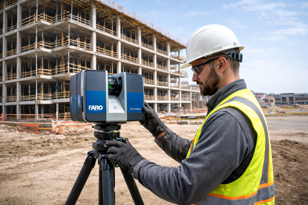
Using high-resolution 3D laser scanners, teams collect millions of measurement points from multiple positions throughout the building. These scans are then registered together to create a unified point cloud that represents the entire structure as it exists in reality.
The result is a complete digital record of the building—accurate, measurable, and accessible to architects, engineers, and project teams. By capturing both inside and outside conditions in a single dataset, scanning eliminates gaps in documentation and provides a reliable foundation for design, renovation, restoration, and facility planning.
Scanning Individual Objects and Architectural Elements
In addition to capturing entire buildings, 3D scanning is often used to document individual objects such as façade features, structural components, or decorative architectural elements. These scans focus on specific parts of a structure that require a higher level of detail or precise documentation.
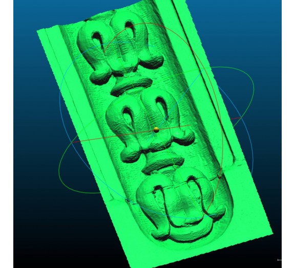
Using handheld or close-range scanners, teams can capture complex geometry such as stone carvings, columns, ornamental moldings, steel connections, or structural joints. The resulting high-resolution data preserves the exact shape, dimensions, and surface details of the object.
This approach is especially valuable for restoration, fabrication, and engineering analysis. Accurate digital models allow teams to study conditions, reproduce damaged elements, or integrate the scanned components directly into design and BIM workflows. By documenting individual elements in detail, scanning ensures that even the smallest but most critical features of a structure are preserved and understood.
What are the advantages of laser surveys?
Quick and most accurate measurements.
Laser surveys capture highly accurate data at rapid speeds.
The laser scanner records millions of data points in mere seconds, ensuring large environments can be surveyed quickly. This is ideal for time-sensitive projects.
The speed of laser scanning is one important reason why it is becoming so widely utilised in a diverse range of industries.
Laser surveying can be used to scan hard-to-reach areas. This is ideal for more complex spaces, in which certain objects may be obscured or otherwise difficult to reach, such as ceiling voids.
Non invasive data capture
Another advantage of laser surveys is that they do not require contact with the existing structure to capture data. This is great for situations in which there are potentially fragile or sensitive objects or environments. For example, in cultural or heritage settings in which preservation is key.
By using laser scanning, laser surveys are a non-invasive method of gathering high-detail data.
Creating 2D Drawings from 3D Laser Scanning Data
A 3D laser scanning project produces a highly accurate point cloud that can serve as the foundation for generating traditional 2D drawings. These drawings can be created in several ways depending on the project requirements, level of detail, and intended use.
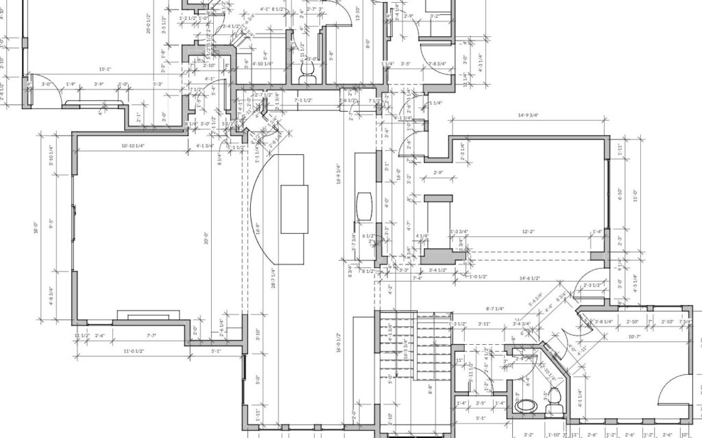
One common approach is exporting drawings directly from a Revit BIM model. In this workflow, the point cloud is first used to build an accurate BIM model of the building or structure. Once the model is completed, standard plans, sections, and elevations can be exported from the model, providing coordinated and fully structured documentation.
Another method is creating drawings directly from the scan point cloud. In this case, the point cloud is referenced in CAD software and used as a visual guide to trace walls, structural elements, and other features. This approach is often used when a full BIM model is not required but accurate 2D documentation is still needed.
A third option is using scan slices for direct visualization. Horizontal or vertical slices of the point cloud can be generated at specific heights or locations. These slices reveal the geometry of the space and allow users to quickly interpret layouts, wall thicknesses, and structural relationships without building a full model.
Together, these methods allow teams to efficiently transform detailed 3D scan data into practical 2D documentation that supports design, renovation, and construction workflows.
Below is an introductory video on 3D laser scanning procedures from Leica, the manufacturer of 3D laser scanners.
Frequently Asked Questions
- How long does it take to 3D scan a building? For a typical residential property, the process might only take a few hours. Larger or more intricate structures, such as commercial buildings or historic monuments, might require several days to capture in full detail. It’s also essential to factor in additional time post-scanning to process the data and create the final 3D model.
- How much does it cost to 3D laser scan a building? The cost to 3D laser scan a building can also vary significantly depending on the same factors affecting the time it takes to do the scan. 3D scanning a small residential property may take a single day and is usually a minimum cost, whereas a mansion with many rooms may take a few days and cost 2-3X more depending on its complexity. A multi-story hotel or apartment building can take 3-5 days depending on the number of rooms, with cost factors including whether it is occupied and the level of modeling detail required in each room. On average it may cost as little as $300 for one room or $1,400 for 3 ornamental stone pieces and $20,000 for the entire 5 story townhouse.
Get the laser surveys services from IDRAWPRO
At IDRAWPRO our team of experienced surveyors offer 3D laser scanning to help you understand your space and create 3D models to help you get the best from it.